E-mail: sales@africanaturaltours.com | +255764415889 |
E-mail: sales@africanaturaltours.com | +255764415889 |
When one talks of hiking to the peak of the mountain, Mount Kilimanjaro or Kenya will come to their minds as the hardest mountains to climb. However, by the end of this 7 Days Rwenzori Trekking Tour - Kilembe Trail you will have known how tougher it is to climb mount Rwenzori than Kilimanjaro or Mt Kenya therefore you should be fit. Ethically this trip takes 8 days to make it to the peak for most people of average fitness and climbing ability however there are people who can do this trek in seven days, hence the seven day trek. But importantly for larger groups we do not recommend seven days as in many cases there will be one person who cannot keep the pace. This trek starts from the Trekkers Hostel in Kyanjuki, Kilembe which is situated 1,450 meters above sea level and just 12 kilometers from Kasese town.
It is best to start the trek by 9 am but you can leave as late as 11am. You walk 2.2km to the UWA rangers post at 1,727 meters, which takes about one hour. Here you pay the gate entrance fee and the rangers brief you on the rules of the National Park.
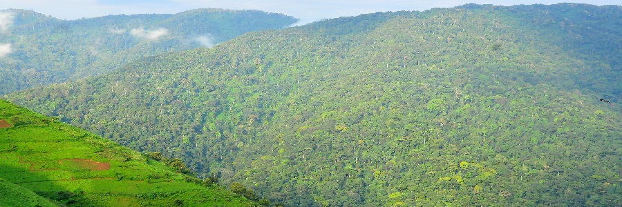
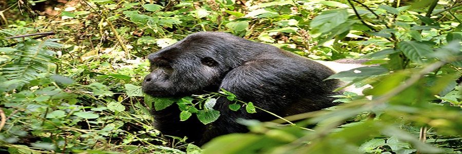
This is the first day of this trip and starts with walking up the valley floor through tall forest trees of the forest Zone. This is a steady climb with multitudes of birds and a chance of seeing blue monkeys scampering off through the forest. At times visitors may see troupes of 15 to 20 black and white Colobus monkeys as they swing through the tree tops. There are rare sightings of the L’Hoest monkey which are part of the Bukonzo cultural emblems and are protected by the virtue of the King or Omusinga or you may hear wild chimpanzee in the distance. There is wide variety of plant species from forest trees to bamboos thickets as you enter the Bamboo Zone which is steep climb with many high steps. In the wet season the bamboo zone is rather muddy and slippery making the going slow but not so bad if you are fit. However the atmosphere and the forest is fantastic as you climb to Kalalama Camp at 3,147 meters which is in the Heather Zone with many tall Heather trees and a good chances to see the ‘Rwenzori Turaco which is bright crimson wings.
After an early breakfast you set off as today you will bypass Mutinda Camp and continue up to Bugata Camp at 4,100 metres. The trail meanders up and over several small knolls along a ridge top then drops down the side of the valley before climbing again and in doing so crosses several small streams and pass close to moss covered waterfalls. You then climb steadily along the side of a beautiful mossy river which tumbles down over the rocks under the Giant Heather trees whose trunks are covered in green moss with old man’s beards hanging from the branches.
The trail twists and turns as you climb up the deep valley, which has an enormous variety of plants and flowers. This valley is unique with many Giant Heather trees creating a beautiful atmosphere often shrouded in mist. The trail here is boggy particularly in the wet season but with a little skill you can step from tussock to tussock to make the going easier. We have put several boardwalks across the worst of the bogs and continuing to build more to make it a little bit easier. You cross the Mutinda valley through the tussock grass and everlasting flowers interspersed with many Giant Lobelias before climbing a steep section up to the Namusangi Valley (3,840 meters), which ends abruptly with sheer waterfalls and fantastic views of Mutinda Peaks.
The Namusangi Valley is wide with many ups and downs and crossing several bogs as the trail climbs steadily to Bugata Camp at 4,062 meters. Bugata Camp is situated way up Bamwanjara Pass high above Bugata Lake with views across Lake Kopello to Weismann’s Peak, which is often covered with snow then down the valley views of Lake Africa and Lake Kanganyika and the many small peaks towards Mutinda Camp. The area is covered with tussock grass, everlasting flowers and Giant lobelia.Bugata Camp will be the spot for the night which has good facilities, solar lights, good toilets and bathrooms where the guides may prepare some warm water in a basin for you to wash. Bugata also has a helicopter pad in case of any need for rescue by helicopter but be warned that a helicopter in Uganda costs around $10,000 per hour flying time which is way more than other countries so you need insurance in case of rescue.
This is another day still on the mission to get to the top of this magnificent mount Rwenzori.You will leave Bugata Camp and you pass up a ridge then drop down slightly before ascending to Bamwanjarra Pass at 4,450 meters where we have a hut should the weather turn bad. From the pass on a clear day you get excellent views of the three main peaks. The trail passes down the valley and around the edge of some bogs and thick ever green vegetation, moss. giant groundsel and lobelia. Here is possibly the best place in all the Rwenzori to observe the Malicite Sunbird as it feeds on the many lobelia flowers and a known breeding site. Farther on there is some steep sections before a steady climb up and over a ridge to Hunwick's Camp which is situated on the top of a deep valley and has good views of Mt Stanley, Mt Baker and WeismannsPeak .
From Hunwick's we pass down and across the valley floor to Lake Kitandara which is very stunning with deep water and beautiful vegetation. From here you climb up Scott Elliott's pass then up the ridge to Margherita Camp 4,485 metres which is situated between some huge rocks and offering some shelter from the strong winds. This is the very spot where the Duke of Abruzzi camped when making his climb to Margherita Peak in 1906.
Wake up at 2am and catch an early breakfast before heading off to climb Mt Stanley at 2.30am. This is necessary as the weather has changed a lot and often even during the dryer season the mountain is closed in with heavy clouds and snow falls from 1 pm to 4pm and this happens within a short period of 10 to 15 minutes as the clouds rise up from the extensive Congo rainforests. This is a very hectic day and the highlight of this whole trek.So you will have to emplore the use of your hiking boots,fit on your crampons from time to time,make good use of your ice axe plus your headlamp and glasses when it shines such that the glittering glacier does not affect your eyes. So you will climb up to the peak of this mountain.So this climb take advice of where the guides suggest to pass.After ascending the peak at 5,109 metres you then pass directly down to Hunwick's Camp at 3.874 metres
From Hunwick’s Camp we start the day by climbing up a ridge towards McConnell’s Prong where you get the best views of all three peaks and Scott Elliott’s Pass before reaching Oliver’s Pass at 4,505 metres. The distance from Hunwick’s Camp to the top of Olivers Pass is 3km The trail then cuts across below Weismann’s Peak to the confluence of the Nyamwamba River which flows down thought Kilembe and Kasese to Lake George in Queen Elisabeth National Park. After crossing the confluence the trail meanders down the valley to Kiharo Camp at which is situated in a deep valley with high cliffs and dense vegetation. On the way down the valley after each bog you will climb over a ridge of stones and earth which seems out of place but actually was pushed there by slow moving glaciers which eventually stopped moving, melted and left a pile of rocks and debris in front of where the glacier once stood.
The trail down the Nyamwamba Valley is mostly downhill and absolutely stunning with beautiful views, moss covered rocks along the river, cascading waterfalls, deep valleys and forests are possibly the best in the Rwenzori Mountains. This part of the trail took us six years to find a way through and a route which is easy enough for tourists to use. In 1937 the explorer and geologist McConnell tried to find a way up this valley but failed and have to turn back and search for another route up the mountain but now you can experience this truly beautiful valley.
A few kilometers from Kiharo Camp the path turns off to the right to pass along the river. In the clear areas you may catch a glimpse of a Duiker quietly feeding in small clearings as you pass along the river. If you wish you may prefer to walk down the river itself hopping across the rocks as you pass down. A few kilometres down the river it becomes very steep with multitudes of waterfalls so we have to move away from the river and follow a narrow ridge to bypass steep sections. At the bottom we again meet the river where there is a huge rock shelter and a place to rest for a while. After crossing a small stream you climb up a gentle slope before turning back down to the river to avoid another set of waterfalls which are impassable. The forest along this section is magnificent and full of life with many birds, primates, dikers and hyrax. A great experience and ending to a fantastic trek.